CGWB 2022 Dataset13,506 WellsPhysics-InformedIndia-NativeRule-based Scoring

goatai.io/climate/varuna

Varuna

Water Intelligence Engine

Cascading hazard analysis for groundwater stress, contamination propagation, and coastal salinity risk. Physics-informed. Fully auditable. India-native.

Wells Monitored

13,506

National

Coverage

India

CGWB 2022

Approach

CBE

Rule-based

Platform

Live

Deployed

Capabilities

Five modules. One cascading water intelligence system.

Each module maps to a specific operational problem. The modules share a common physics-informed reasoning layer — outputs from one feed boundary conditions for the next.

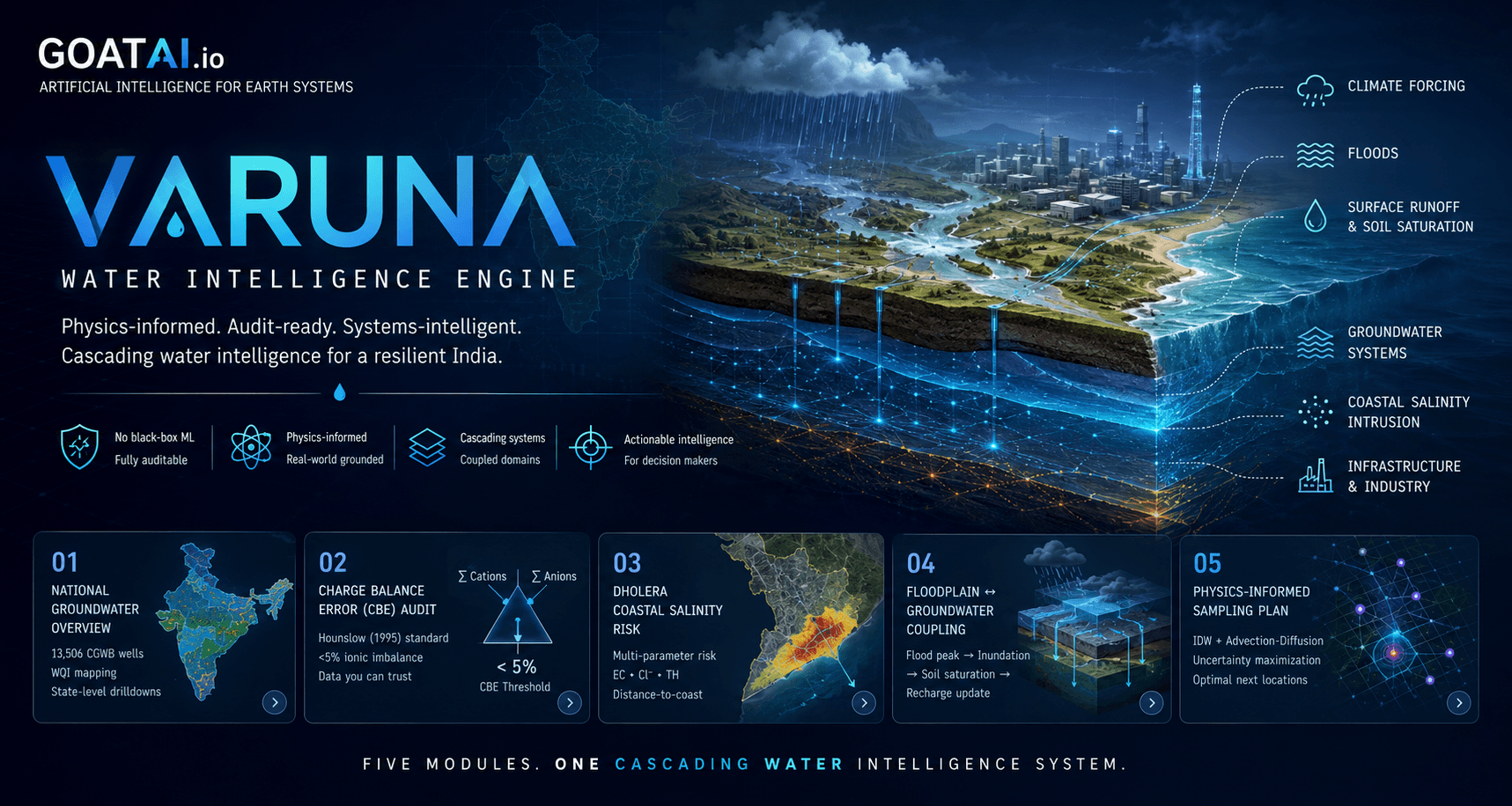
National Groundwater Overview

Problem

No unified visibility into national groundwater quality and contamination patterns across India's 13,506 monitored wells.

Solution

Interactive WQI map with spatial contaminant tracking, coverage audit, and data quality validation layer.

WQI Mapping13,506 WellsContaminant Tracking

Charge Balance Error Audit

Problem

Pre-filtered or biased datasets conceal real contamination signals and introduce systematic error into downstream analysis.

Solution

CBE-based statistical rigor (Hounslow 1995 standard, <5% threshold) flags samples with ionic imbalance before any inference runs.

Hounslow 1995Bias Detection<5% CBE Threshold

Dholera Coastal Salinity Risk

Problem

Smart city construction at Dholera requires water security assessment as coastal aquifers face rising salinity pressure.

Solution

Distance-to-coast + EC + Cl/TH ratio composite scoring. Physics-informed sampling plan identifies where risk is highest and data is thinnest.

Cl/TH RatioEC ScoringCoastal Intrusion

Floodplain Groundwater Coupling

Problem

Flood intelligence is incomplete without modeling how inundation events cascade into aquifer recharge dynamics.

Solution

Inundation zone mapping coupled with aquifer recharge event analysis — flood peak triggers recharge boundary condition update.

Recharge CascadeInundation CouplingFlood Physics

Physics-Informed Sampling Plan

Problem

Sparse sensor networks leave critical blind spots. Statistical sampling is insufficient for heterogeneous aquifer systems.

Solution

IDW interpolation + advection-diffusion transport physics + greedy uncertainty maximization selects optimal next-well locations.

IDW InterpolationAdvection-DiffusionUncertainty Maximization

Data & Methodology

Rule-based risk scoring. No black-box ML. Fully auditable.

Every score in Varuna is traceable to its source data and formula. Institutional buyers and regulators can audit the full inference chain.

Data Source

CGWB 2022

Central Groundwater Board 2022 national survey. 13,506 wells across all states. Data quality varies by region — the CBE audit systematically identifies and quarantines unreliable samples before analysis proceeds.

Validation Standard

Hounslow 1995

Charge Balance Error threshold of <5% is applied to all samples. Samples outside this range are flagged as statistically questionable. This prevents biased data from propagating through the risk scoring pipeline.

Risk Scoring

Rule-Based

Composite risk scores are computed using physics-grounded weighting: distance-to-coast, EC concentration, chloride/total hardness ratio, and WQI. No black-box ML. Every score is traceable to source data and formula.

Sampling Optimization

Physics + Uncertainty

IDW spatial interpolation estimates contaminant fields from known sample points. Advection-diffusion physics models transport pathways. Greedy uncertainty maximization selects locations that reduce prediction variance most efficiently.

Validation methodology follows Hounslow (1995) ionic balance standards. Risk scoring formulas are documented in the CGWB 2022 audit preprint — available prior to EarthArXiv submission on request.

Request methodology doc

Live Platform

Varuna is deployed and running now

Explore the national groundwater audit, Dholera coastal risk scoring, and physics-informed sampling plan in the live deployment.

Live at varuna.goatai.io

The live deployment includes the national WQI map, CBE audit layer, Dholera coastal salinity risk visualisation, floodplain coupling overlay, and physics-informed sampling plan.

Explore Varuna Platform →

National Overview

13,506 well WQI map with contaminant filtering and state-level drill-down

Dholera Coastal

Salinity risk composite scoring with sampling plan output for the AOI

Floodplain Coupling

Inundation zone overlay with aquifer recharge event timeline

Systems Context

Water isn't isolated. Varuna reasons across coupled domains.

Varuna is the water module within GoatAI's larger systems intelligence platform. Each coupling below is a live interface — outputs from one domain become boundary conditions for the next.

FloodGroundwater

Flood peak → inundation → soil saturation → aquifer recharge boundary update. Excess precipitation does not leave the system at the surface.

ClimateGroundwater

Earth-2 downscaled precipitation forecast (Phase 2) feeds as recharge boundary condition. 30-day climate forcing drives water table projections.

InfrastructureGroundwater

Power plants, irrigation networks, and smart cities draw from shared aquifer systems. Infrastructure stress propagates to groundwater availability timelines.

IndustrialGroundwater

Steel plants, refineries, and thermal power require water security planning. Industrial contamination events trigger cascading WQI degradation downstream.

Partnership Pathways

Three entry points. One platform.

Varuna is built for institutional credibility, commercial deployment, and research validation simultaneously. Choose your engagement model.

Institutional

State Boards · NDMA · Utilities

Integrate Varuna into your state water stress monitoring framework. Dholera pilot (Phase 1 proposal submitted via Poornima College) demonstrates the coastal salinity workflow.

Commercial

Renewable · Real Estate · Industry

90-day pilot pathway for operational water intelligence. ReNew Power, Lodha Palava, and thermal plant operators are target deployment contexts for CSR, ESG, and operational risk.

Culturiq Research Pvt. Ltd.

Discuss pilot scope
Research

IWMI · IIT Delhi · ICIMOD

Validate Varuna's forecasting across new regions and aquifer types. IWA SCED-2026 and RCRM 2026 abstracts are active credibility markers. Open methodology, open invitation.

business@goatai.io

Propose validation study

Roadmap

Building toward sovereign water systems intelligence

Ambitious but grounded. Each phase is gated on real validation — no timeline slips from overcommitting on features.

Phase 1

Current

Live

National Audit + Dholera Coastal

CGWB 2022 national groundwater audit, CBE-based data validation, Dholera coastal salinity risk scoring, and floodplain-aquifer coupling prototype. Live at varuna.goatai.io.

Phase 2

Q3 2026

Building

Earth-2 Climate Forcing Integration

30-day precipitation-driven aquifer recharge forecast using NVIDIA Earth-2 downscaling. Climate forcing becomes a Varuna boundary condition for water table projections.

Phase 3

Q4 2026

Planned

Live Sensor Monitoring

Real-time sensor network integration with anomaly detection for contamination onset. Early warning when EC or ion concentrations deviate beyond safe thresholds.

Phase 4

2027

Planned

Dholera 3D Digital Twin

Full NVIDIA Omniverse integration for Dholera: 3D groundwater model with interactive scenario testing, coastal salinity propagation visualization, and infrastructure impact overlay.

Research & Publications

Building in public. Science-backed. Open methodology.

Varuna is grounded in peer-reviewed validation standards and active conference submissions. Open-source tools underpin the inference layer.

CGWB 2022 National Groundwater Audit

Preprint

EarthArXiv — in preparation

Statistical audit and WQI analysis of India's 13,506-well national monitoring dataset. CBE-based validation, contaminant spatial analysis, and sampling plan methodology.

Watershed-to-Coast Hazard Cascade Framework

Conference

IWA SCED-2026 — submitted

Cascading water systems analysis from upstream aquifer stress through floodplain coupling to coastal salinity intrusion.

RCRM 2026 — IIT Jammu

Conference

July 2026

Water systems cascade reasoning under compound climate stress. Validation methodology for physics-informed groundwater inference.

wie-api

Open Source

github.com/prabhat284/wie-api

Open-source Water Intelligence Engine — geospatial reasoning API powering Varuna's spatial analysis and sampling optimization.

github.com/prabhat284/wie-api

ATOM OSS SDK

Open Source

github.com/culturiqai/atom-oss-sdk

Geospatial AI and multiphysics toolkit. Open development. Core infrastructure for Varuna's physics-informed inference layer.

github.com/culturiqai/atom-oss-sdk

Varuna — Water Intelligence Engine

Explore the Platform

National groundwater audit, coastal salinity risk, floodplain coupling, and physics-informed sampling plan — live and accessible now.

Partnership, research collaboration, or deployment inquiries: business@goatai.io